
GIS Skills
- ArcGIS Pro
- ArcGIS Online
- ArcGIS Field Maps
- ArcPy with Python
- QGIS
- Coordinate Systems, Projections & Transformations
- etc
- Geoprocessing
- Spatial Analysis
- Image Analysis
- Remote Sensing
- Mapmaking
- Model Builder
- FDGC Compliant Metadata
- etc
A few examples of GIS Analyses & Outputs I’ve performed are provided within this page below.
Additionally, the following link will take you to my ArcGIS StoryMap describing a GIS and Urban Forestry project I’ve implemented, which includes embedded apps and dashboards I’ve created using ArcGIS Online, ArcGIS Pro and ArcGIS Field Maps: GIS Skills Demo
I have performed hundreds of additional GIS analyses and created hundreds of maps for other various organization owned by them, which are not shareable.
Contact me to discuss any additional proof of skills desired.
Figure 1: ArcGIS Pro map of the Twelvemile Lake surface area change over the years. Water pixels were mapped from Landsat 8 image bands utilizing the Normalized Difference Water Index (NDWI). The shorelines were then extracted and compared.
Some tools utilized include Batch Raster Calculator, Con, Raster to Polygon, Batch Add Field, Merge, Calculate Geometry, Create Bar Chart, Attribute Table Editing and Symbology.
Skills demonstrated: ArcGIS Pro, Geoprocessing, Raster Analysis, Remote Sensing & Mapmaking
Figure 2: The Hydrology tools in ArcGIS Pro were used to generate the Big Muddy Watershed drainage area shown here, along with land classification delineation starting with data from the National Land Cover Database. Two DEMs overlapping the area of interest were obtained from the USGS National Map Download application, and the drainage area and main river networks were derived from this. The results were compared to the National Hydrography Database (NHD) WBD and flowlines and are in agreement. Land classifications originated from the National Land Cover Data (obtained from the Multi-Resolution Land Characteristics Consortium), and were refined down to the classifications shown.
Some tools utilized include Mosaic to New Raster, Fill, Flow Direction, Flow Accumulation, Reclassify, Raster to Polyline, Create New (shapefile), Snap Pour Point, Watershed, Raster to Polygon, Clip, Clip Raster, Apply Symbology From Later, Calculate Geometry, Calculate Fields, Attribute Table Editing and Symbology.
Skills demonstrated: ArcGIS Pro, Geoprocessing for Hydrology, Accessing National Databases, Raster Analysis, Creating and Editing Shapefiles & Mapmaking
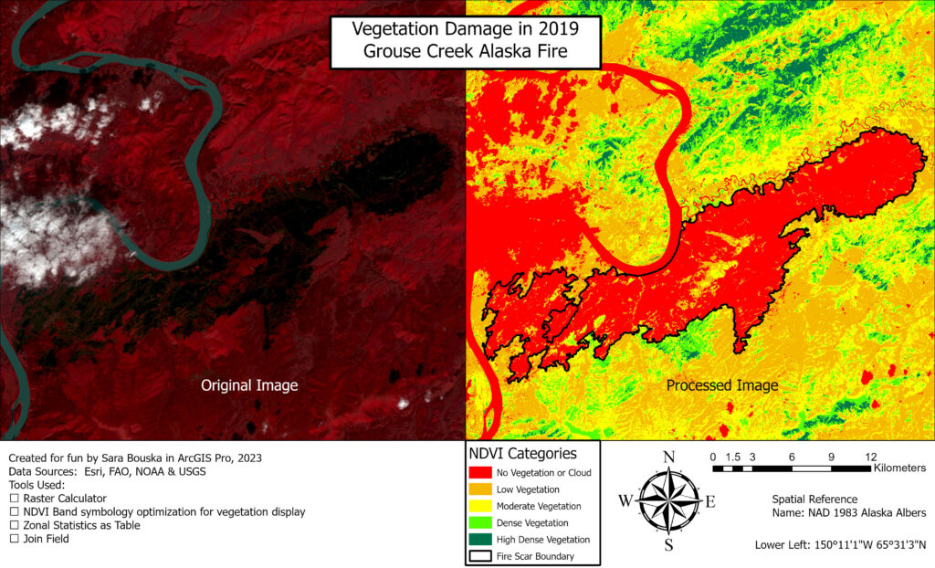
Figure 3: ArcGIS Pro map from processed Landsat 8 imagery for vegetation assessment of a post-fire region using the Normalized Difference Vegetation Index (NDVI) classification scheme.
Skills demonstrated: ArcGIS Pro, Geoprocessing, Remote Sensing, Image Analysis, Land Classification & Mapmaking
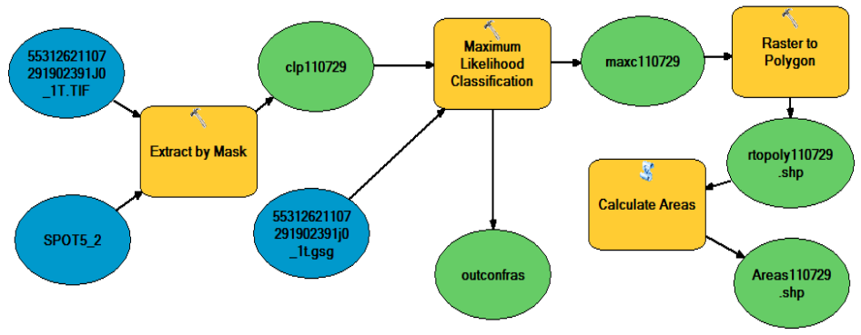
Figure 4: Use of Model Builder to create a process where SPOT image files and water spectral signatures inputs output water polygons and contemporaneous water surface area quantities in the high desert. Land classifications were trained via a supervised maximum likelihood classification scheme.
Skills Demonstrated: GIS Process building in ArcGIS, Model Builder, Geoprocessing & Remote Sensing.
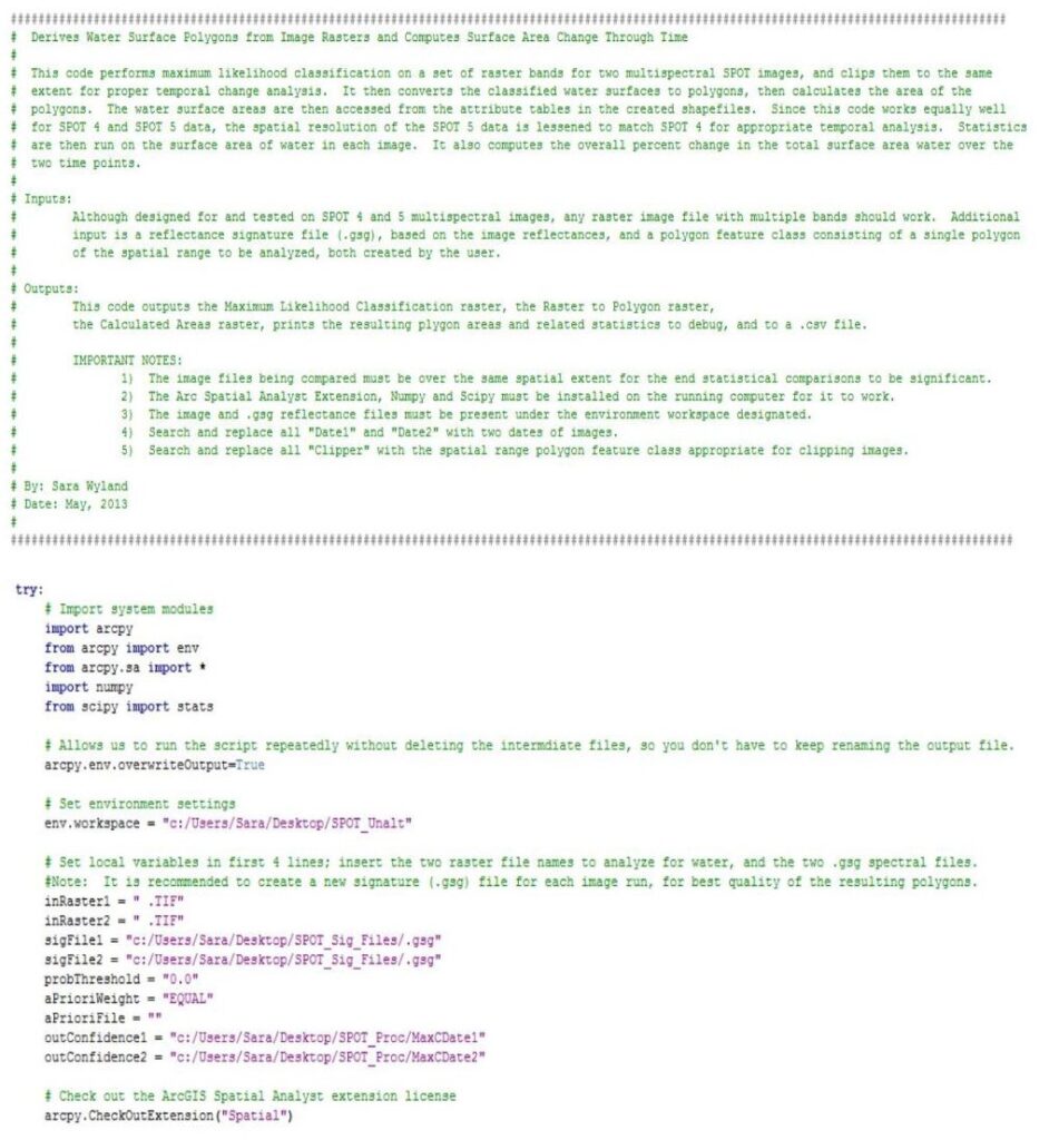
Figure 5: Unique Python script (pages 1 & 2 of 7) for water availability and temporal change analysis extracted from SPOT images in Oregon’s remote high desert.
Skills Demonstrated: Python coding, GIS Process building in ArcPy & ArcGIS, Geoprocessing & Remote Sensing.
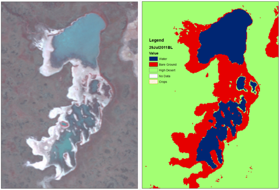
Figure 6: SPOT Image & Associated Output of Customized Analysis for Land Type Classification using Python and ArcGIS.
Skills Demonstrated: Remote Sensing, ArcMap, Image Analysis, Geoprocessing & Mapmaking